WDFW Beach Season Information
Washington Department of Fish and Wildlife does not regulate shellfish harvest on federally owned beaches. See map below for harvest areas. Clamming and crabbing are closed in designated harvest areas October 1 through May 14.
The Graveyard Spit portion of Dungeness Spit is CLOSED year-round for clams, mussels, and oysters. Public access to Graveyard Spit is prohibited to protect nesting birds and other wildlife.
WDFW shellfish seasons indicate the specific times of year when harvesting is permitted. Before heading to the beach, please also check the Department of Health (DOH) information below which is related to health of the shellfish and may be updated daily. To harvest on this beach, it must be both during the WDFW approved season and approved by the DOH.
The clam resource on Dungeness Spit is limited, especially on the exposed western side of the spit. There is better habitat and clam resource on the eastern side in Dungeness Bay near the base of the spit and along the spit northward. Available species here include native littleneck clams, butter clams, eastern softshell clams, and varnish clams.
All beaches on Dungeness Spit are in Dungeness National Wildlife Refuge and public access is limited in some areas to protect nesting birds and other wildlife. Please obey all signs and avoid restricted areas. See map of Dungeness Spit with harvest areas and clam seasons. It is also illegal to remove anything from the beach other than legal amounts of shellfish. This includes shells and driftwood.
Cline Spit and Sequim Bay State Park are better harvest alternatives with more clams.
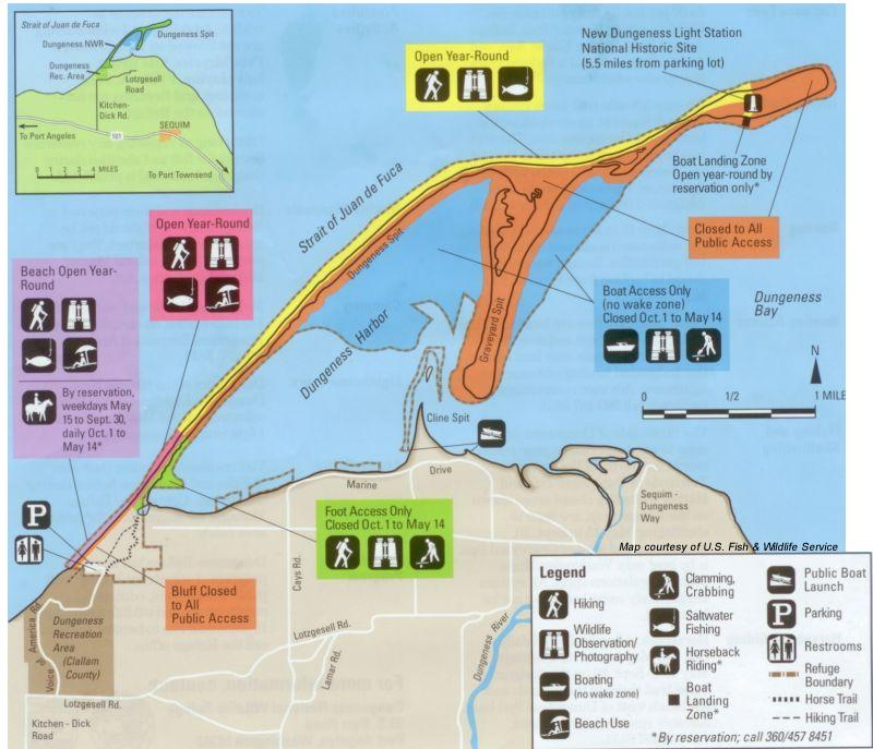
From Highway 101, four miles west of Sequim and 11 miles east of Port Angeles, turn north onto Kitchen-Dick Road (look for the sign to Dungeness on the highway). Travel approximately three and a half miles. The entrance to Dungeness Recreation Area will be on your left. The trailhead for the beach and spit is at the north end of the Recreation Area. The trail to the spit is short but steep. There is a fee for entering the National Wildlife Refuge which begins at the trailhead.
All facilities at Dungeness are located in the Dungeness Recreation Area. These include camping, potable water, a picnic area, vault toilets and horse trails. There is a daily use fee per family for entering the Wildlife Refuge.