WDFW Beach Season Information
Clam, mussel, and oyster seasons OPEN for harvest year-round.
WDFW shellfish seasons indicate the specific times of year when harvesting is permitted. Before heading to the beach, please also check the Department of Health (DOH) information below which is related to health of the shellfish and may be updated daily. To harvest on this beach, it must be both during the WDFW approved season and approved by the DOH.
![]() DNR-409 (Discovery Bay)
is accessible by boat only. There is no upland access to this beach.
DNR-409 (Discovery Bay)
is accessible by boat only. There is no upland access to this beach.
Not much is known about clam populations on DNR-409 but surveys conducted in the late 1980s indicate fair numbers of native littleneck clams and butter clams. There may also be some Manila clams and cockles on this beach. Oysters are not expected to be common at this location.
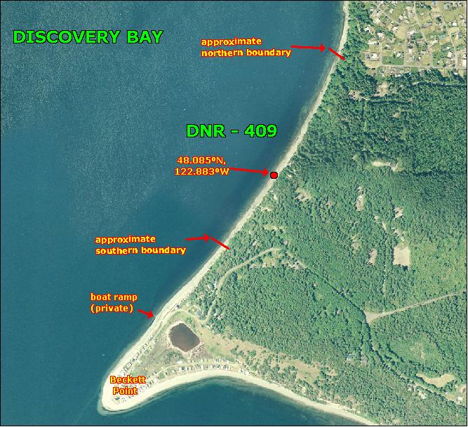
DNR-409 is boat access only. There is no upland access to this beach. There is about 3,000 linear feet of public tidelands boundary to boundary (see photo of beach). The northern boundary of DNR-409 about 0.7 miles south of the Cape George Marina. The southern boundary is just under a half mile north of the tip of Beckett Point. The GPS coordinates for the midpoint of this beach are: 48.085ºN, 122.883ºW. Harvesters are advised to use these coordinates to stay near the midpoint of this beach to avoid trespassing.
Nearest boat ramps: The Gardiner boat ramp (located about 12 miles east of Sequim just north of Highway 101) is just over two miles by boat from the midpoint of DNR-409.
None. There is a pit toilet at the Gardiner Boat Ramp. There are facilities for boaters at John Wayne Marina in Sequim Bay.