WDFW Beach Season Information
Clam, mussel, and oyster seasons OPEN for harvest year-round.
WDFW shellfish seasons indicate the specific times of year when harvesting is permitted. Before heading to the beach, please also check the Department of Health (DOH) information below which is related to health of the shellfish and may be updated daily. To harvest on this beach, it must be both during the WDFW approved season and approved by the DOH.
Harvest opportunities on Chimacum Creek Tidelands (north part) include good digging for butter clams along the tidal channel of Chimacum Creek north of the tidal channel towards Kala Point. Native littleneck clams and horse clams are also found in this area. Eastern softshell clams can be found along the upper creek channel near the mouth.
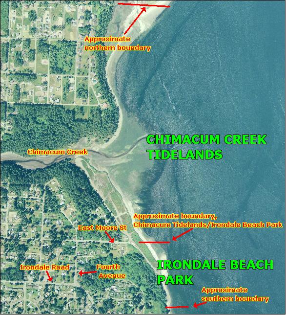
To reach the site from the west on Highway 104 take the Chimacum/Port Townsend/Quilcene exit (a left hand turn) and travel north on Center Road for about 10 miles to Chimacum. Go straight through the four-way stop and continue north about three miles through Port Hadlock on Irondale Road to Fourth Avenue. Take a right and follow Fourth Avenue for three blocks to east Moore Street. Take a right. East Moore Street is the access road for Chimacum Creek Tidelands and Irondale Beach. The boundary between the two beaches is about where East Moore Street enters the Chimacum Tidelands property (see beach map). Chimacum Creek Tidelands is to the left (north) and Irondale Beach is to the right (south). There is parking for Chimacum Creek Tidelands along the access road. At the present time there is no drive in access to Chimacum Creek Tidelands. Irondale Beach can be accessed from the access road or from the parking lot at the end of the the access road.
To reach the site from the east on Highway 104 from the Hood Canal Bridge take the Port Townsend/Port Ludlow exit (a right hand turn) and travel north on Beaver Valley Road (Highway 19) for about seven miles to Chimacum. Go straight through the four-way stop and continue north about three miles through Port Hadlock on Irondale Road to Fourth Avenue. Take a right and follow Fourth Avenue for three blocks to east Moore Street. Take a right. East Moore Street is the access road for Chimacum Creek Tidelands and Irondale Beach. The boundary between the two beaches is about where East Moore Street enters the Chimacum Tidelands property (see beach map). Chimacum Creek Tidelands is to the left (north) and Irondale Beach is to the right (south). There is parking for Chimacum Creek Tidelands along the access road. Irondale Beach can be accessed from the access road or from the parking lot at the end of the the access road.
There is a portable toilet and information signs at the Irondale Beach Parking lot.