WDFW Beach Season Information
Clam, mussel, and oyster seasons OPEN for harvest year-round.
Please be aware of shellfish safety-related boundaries in this area. WDFW cannot recommend harvesting south of the north end of the Commander's Beach House property. While the area north of this point ("North Point Hudson") is classified as Approved and safe for shellfish harvest, the beach adjacent to the south (which begins at the south end of the Commander's Beach house property) is not classified by Department of Health and harvest there is at your own risk. Further south of there (beginning in front of and extending south of Dock's Restaurant toward the marina), nearby the Point Hudson Marina is classified as Prohibited and not a safe shellfish harvesting area.
WDFW recommends staying north of the Commander's Beach House property for shellfish harvesting. Refer to the Shellfish Safety Map below for approximate boundary depictions.
WDFW shellfish seasons indicate the specific times of year when harvesting is permitted. Before heading to the beach, please also check the Department of Health (DOH) information below which is related to health of the shellfish and may be updated daily. To harvest on this beach, it must be both during the WDFW approved season and approved by the DOH.
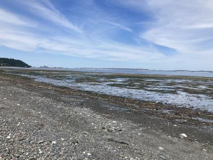
This beach, while large and beautiful, is not a great beach for clamming. There are a few butter clams to be found in patches of favorable habitat, and a low density of horse clams throughout. A cockle or two may be found here too, although they are popular with the abundant local gulls. There are no oysters on this beach.
This beach probably has its highest value as a nice walking, tidepooling, and wildlife viewing beach.
There is ample parking in the Point Hudson Marina area.
There are outhouses adjacent to the marina, parking is easy, and beach access is obvious and easy from the marina area of Point Hudson.
The lagoon adjacent to this beach is an annual migratory stopover for brants, Heerman's gulls, black turnstones, and a variety of other species.