WDFW Beach Season Information
Clam, mussel, and oyster seasons OPEN for harvest year-round.
WDFW shellfish seasons indicate the specific times of year when harvesting is permitted. Before heading to the beach, please also check the Department of Health (DOH) information below which is related to health of the shellfish and may be updated daily. To harvest on this beach, it must be both during the WDFW approved season and approved by the DOH.
![]() South Zelatchet Point
is accessible by boat only. There is no upland access to this beach.
South Zelatchet Point
is accessible by boat only. There is no upland access to this beach.
This beach is mostly rocky and digging is difficult but productive for butter clams and native littleneck clams in the mid-low tidal zone. There are also some Manila clams in pockets of gravel near the north end of the beach in the mid-high tidal zone. Some horse clams and cockles are found on the beach. Geoducks can be found in the sand at extreme low tides (-2.0 feet or lower) below the rocky zone.
This is an excellent oyster beach. The waters off South Zelatched Point stay colder in the summer than most of Hood Canal and the oysters here are known to stay in good condition for most of the summer.
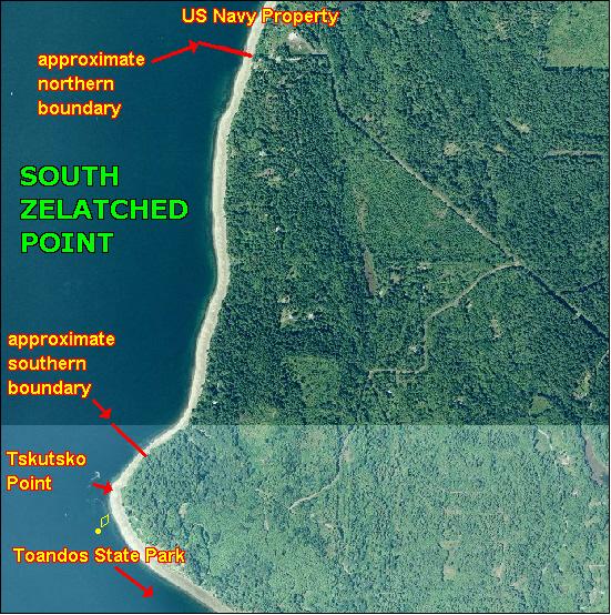
South Zelatched Point is boat access only (see beach map). There is no upland access. The adjacent property to the north is owned by the U.S. Government and is posted as such. The north boundary of South Zelatched Point is about 550 yards south of the Navy pier. The south end of this beach is just north of the Tskutsko Point navigation light and the adjoining property is Toandos Peninsula State Park, which is also a public beach. Approximate GPS coordinates to the midpoint of this beach are: 47.7o N, 122.826o W.
Nearest boat ramps: The Misery Point ramp (located about 3 miles from Seabeck on Misery Point Road) is about 3 nautical miles by boat from the approximate midpoint of South Zelatched Point. Point Whitney ramp (located north of Brinnon on Bee Mill Road) is about 3.8 nautical miles by boat from the approximate midpoint of South Zelatched Point.
None. There are restrooms at Point Whitney and a vault toilet at Misery Point ramp. There are also facilities for boaters at Pleasant Harbor Marina (south of Brinnon) and Seabeck Marina.