WDFW Beach Season Information
Clam, mussel, and oyster seasons OPEN for harvest year-round.
WDFW shellfish seasons indicate the specific times of year when harvesting is permitted. Before heading to the beach, please also check the Department of Health (DOH) information below which is related to health of the shellfish and may be updated daily. To harvest on this beach, it must be both during the WDFW approved season and approved by the DOH.
![]() Toandos Peninsula State Park
is accessible by boat only. There is no upland access to this beach.
Toandos Peninsula State Park
is accessible by boat only. There is no upland access to this beach.
This beach is mostly rocky and digging is difficult but productive for butter clams and native littleneck clams in the mid-low tidal zone. There are also some horse clams and cockles. Geoducks can be found in the sand at extreme low tides (-2.0 or lower) below the rocky zone.
This is an excellent oyster beach. The waters off Toandos Peninsula State Park stay colder in the summer than most of Hood Canal and the oysters here are known to stay in good condition for most of the summer.
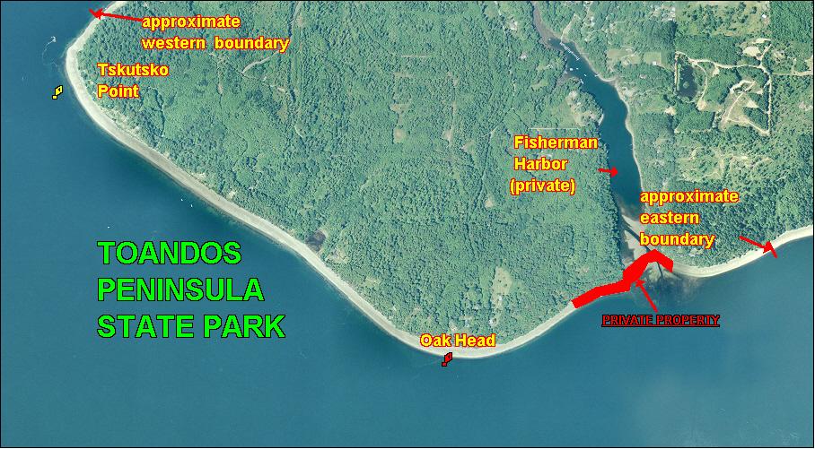
Toandos Peninsula State Park is boat access only (see beach map). There is no upland access. This beach is split into two parts. The northwest boundary of Toandos Peninsula State Park is just north of the Tskutsko Point navigation light. The beach to the north of the boundary is South Zelatched Point, also a public beach. The southeast boundary of the beach is about 600 yards east of the Oak Head navigation light. GPS coordinates for the Oak Head navigation light are:47.6818o N, 122.811oW. GPS coordinates for the Tskutsko Point navigation light are: 47.6912o N, 122.833o W. The distance between the two lights is about one mile.
Approximately 500 yards east of the southeast boundary described above there is another stretch of Toandos Peninsula State Park beach that begins about 100 yards east of the gap between the spit to the west and the headland to the east which form the entrance to Fisherman Harbor (see beach map). There are no markers for this boundary. This portion of Toandos Peninsula State Park is about 440 yards long. The east boundary is not marked, but it is about 210 yards from the middle of the beach. The GPS coordinates for the middle of this beach are: 47.6857º N, 122.795ºW. The entrance to Fisherman Harbor and approximately 420 yards of beach to the west are private. It is recommended that harvesters stay near the midpoint of the beach or well within the described boundaries to avoid trespassing.
Nearest boat ramps: The Misery Point ramp (located about 3 miles from Seabeck on Misery Point Road) is about 2.3 nautical miles by boat from the Oak Head navigation light. Point Whitney ramp (located north of Brinnon on Bee Mill Road) is about 4.3 nautical miles by boat from the Tskutsko Point navigation light.
None. There are restrooms at Point Whitney and a vault toilet at Misery Point ramp. There are also facilities for boaters at Pleasant Harbor Marina (south of Brinnon) and Seabeck Marina.