WDFW Beach Season Information
Clam, mussel, and oyster seasons OPEN for harvest year-round.
WDFW shellfish seasons indicate the specific times of year when harvesting is permitted. Before heading to the beach, please also check the Department of Health (DOH) information below which is related to health of the shellfish and may be updated daily. To harvest on this beach, it must be both during the WDFW approved season and approved by the DOH.
![]() North Tabook Point
is accessible by boat only. There is no upland access to this beach.
North Tabook Point
is accessible by boat only. There is no upland access to this beach.
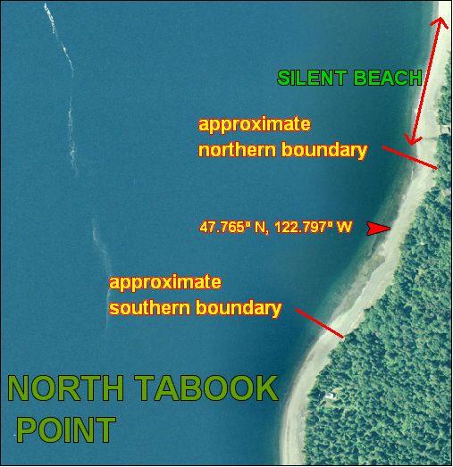
North Tabook Point is boat access only. There is no upland access. The beach is about 480 yards long from boundary to boundary. The boundaries are not marked. It is recommended that harvesters stay well within 200 yards of the approximate midpoint of this beach to avoid trespassing. Approximate GPS coordinates of the midpoint of North Tabook Point are: 47.765oN, 122.796o W.
Nearest boat ramps: Point Whitney ramp (located north of Brinnon on Bee Mill Road) is about 2.1 nautical miles by boat to North Tabook Point. The Quilcene Marina ramp (located about 1 mile south of Quilcene on Linger Longer Road) is about 3.8 nautical miles by boat from North Tabook Point.