WDFW Beach Season Information
Clam, mussel, and oyster seasons OPEN for harvest year-round.
WDFW shellfish seasons indicate the specific times of year when harvesting is permitted. Before heading to the beach, please also check the Department of Health (DOH) information below which is related to health of the shellfish and may be updated daily. To harvest on this beach, it must be both during the WDFW approved season and approved by the DOH.
![]() DNR 57 (Toandos Peninsula)
is accessible by boat only. There is no upland access to this beach.
DNR 57 (Toandos Peninsula)
is accessible by boat only. There is no upland access to this beach.
Not much is known about DNR-57 clam populations, but it is a typical rocky Hood Canal beach that should have butter clams available in the mid-low tidal zone as well as cockles, native littleneck clams, and horse clams. Geoducks may be found at extreme low tides (-2.0 feet or lower) below the rocky zone.
This is a good beach for oysters.
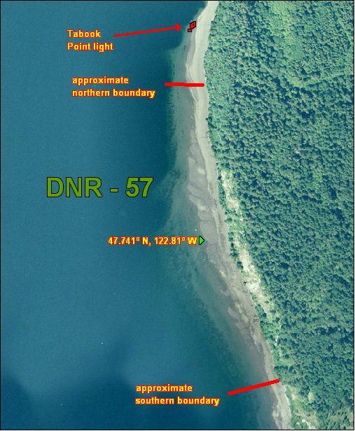
DNR-57 is boat access only. There is no upland access. The north boundary of this beach is located about 600 feet south of the navigation light at Tabook Point. DNR-57 is about 1,000 yards from boundary to boundary. The south boundary is not marked (see beach map). Approximate GPS coordinates of the south boundary are: 47.738º N, 122.807º W. GPS coordinates for the midpoint of DNR-57 are: 47.741º N, 122.809º W. When in doubt, please stay well within the approximate boundaries to avoid trespassing.
Nearest boat ramps: Point Whitney ramp (located north of Brinnon on Bee Mill Road) is about 2 nautical miles by boat from DNR-57. The Misery Point ramp (located about 3 miles from Seabeck on Misery Point Road) is about 5.6 nautical miles by boat from DNR-57. Quilcene Marina (located 1 mile south of Quilcene on Linger Longer Road) is about 4.3 nautical miles by boat from DNR-57.