WDFW Beach Season Information
Clam, mussel, and oyster seasons OPEN for harvest year-round.
Map areas identify approximate public property boundaries and should not be considered legal property boundaries. Many of these public beaches have no upland entrance and must be accessed by boat. Please respect adjacent private property. This map is provided for informational purposes only. The accuracy of this map is not guaranteed.
WDFW shellfish seasons indicate the specific times of year when harvesting is permitted. Before heading to the beach, please also check the Department of Health (DOH) information below which is related to health of the shellfish and may be updated daily. To harvest on this beach, it must be both during the WDFW approved season and approved by the DOH.
![]() Bolton Peninsula
is accessible by boat only. There is no upland access to this beach.
Bolton Peninsula
is accessible by boat only. There is no upland access to this beach.
Not much is known about Bolton Peninsula clam populations, but surveys in the 1990s found evidence of butter clams, cockles, native littleneck clams, Manila clams, horse clams and geoducks.
This is a good beach for oysters.
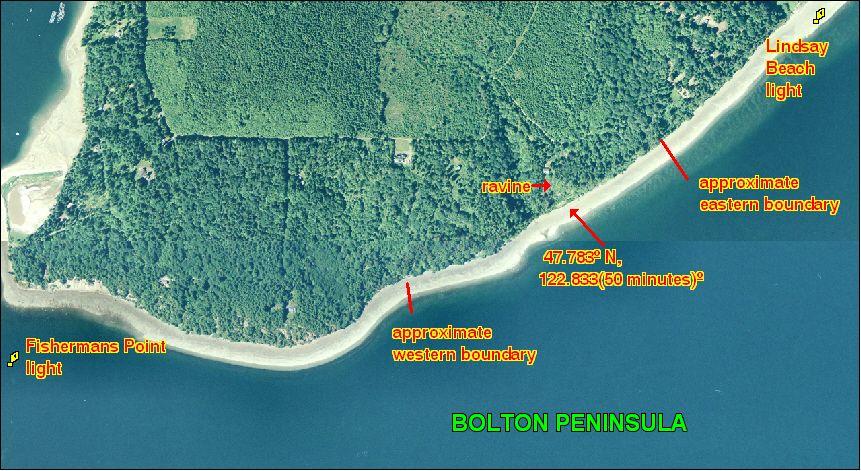
Bolton Peninsula is boat access only. There is no upland access (see beach map). The western boundary of this beach is located 0.65 nautical miles east of the Fishermans Point navigation light. The beach is approximately 0.44 nautical miles long from boundary to boundary. Neither boundary is posted. The eastern boundary is approximately 0.24 nautical miles southwest of the Lindsay Beach navigation light. The eastern boundary is near the base of a steep, high bluff. A good landmark for this beach is the ravine near the midpoint of Bolton Peninsula. The ravine is just east of the area known as Red Bluff. The approximate GPS coordinates of the ravine/midpoint of Bolton Peninsula are: 47.783 o N, 122.833(50 minutes)o W. When in doubt, please stay near the ravine to avoid trespassing (see beach map).
Nearest boat ramps: Point Whitney ramp (located north of Brinnon on Bee Mill Road) is about 1.4 nautical miles by boat from Bolton Peninsula. Quilcene Marina (located 1 mile south of Quilcene on Linger Longer Road) is about 2.2 nautical miles by boat from Bolton Peninsula.
None. There are restrooms at Point Whitney. There are restrooms and facilities for boaters at Quilcene Marina.