WDFW Beach Season Information
Clam, mussel, and oyster seasons OPEN for harvest year-round.
WDFW shellfish seasons indicate the specific times of year when harvesting is permitted. Before heading to the beach, please also check the Department of Health (DOH) information below which is related to health of the shellfish and may be updated daily. To harvest on this beach, it must be both during the WDFW approved season and approved by the DOH.
![]() DNR-48 (Hood Canal)
is accessible by boat only. There is no upland access to this beach.
DNR-48 (Hood Canal)
is accessible by boat only. There is no upland access to this beach.
This beach is rocky and digging is difficult but productive for butter clams, large native littleneck clams and horse clams in the mid-low tidal zone. A good technique for digging butter clams in rocky substrate is to target individuals or small groups of butter clams by looking for the rectangular siphon holes that indicate their presence. This method takes less time and energy than random digging. A wide tined potato fork works well for digging butter clams in rocky substrate.
This is a good oyster beach. A lot of the oysters on this beach are attached to rocks. They can be harder to shuck than single or cluster oysters.
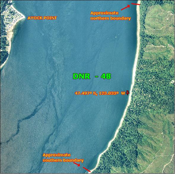
DNR-48 is boat access only. There is no upland access to this beach. DNR-48 is about one and a half miles long. The north end of the beach is about one and a quarter miles south of Chinom Point. The north boundary is near a small un-named point. There is currently a No Trespassing sign at this spot. Another landmark is Ayock Point which is almost straight across Hood Canal from the north end of DNR-48. The southern boundary of this beach is not marked but it is very close to a concrete bulkhead and staircase. There is also an A-frame cabin on the bank above the beach a short distance north of the southern boundary. A good current landmark for DNR-48 is an old abandoned blue boat that is grounded high on the beach near the middle of the beach. Approximate GPS coordinates to the midpoint of DNR-48 are: 47.497º N, 123.033º W. It is recommended that harvesters use these coordinates or the blue boat as the best landmarks for this beach and stay near these areas to avoid trespassing.
Nearest boat ramps: Triton Cove State Park ramp (located about six miles south of Brinnon on Highway 101) is just over seven and a quarter miles by boat from DNR-48. Please note there is a fee to use the boat ramp at Triton Cove State Park.
None. There is a vault toilet at Triton Cove State Park and facilities for boaters at Pleasant Harbor Marina.