WDFW Beach Season Information
Clam, mussel, and oyster seasons OPEN for harvest year-round.
WDFW shellfish seasons indicate the specific times of year when harvesting is permitted. Before heading to the beach, please also check the Department of Health (DOH) information below which is related to health of the shellfish and may be updated daily. To harvest on this beach, it must be both during the WDFW approved season and approved by the DOH.
![]() East Dabob
is accessible by boat only. There is no upland access to this beach.
East Dabob
is accessible by boat only. There is no upland access to this beach.
This is an excellent beach for Manila clams and native littleneck clams. The best spot is above the oyster beds in sand and gravel substrate. Horse clams and geoducks can be found in the lower tide zone below the oysters in sand and mud. Cockles are found in good numbers near or on the surface on the extensive sand flats.
This is an excellent beach for oysters. Before it was acquired by WDFW, this beach was a commercial oyster beach.
This is a boat access only site. There is no upland access to this beach. The closest boat ramps are the Point Whitney ramp (about 4.5 miles away), located north of Brinnon on Bee Mill Road and Quilcene Marina ramp (about 5.7 miles away), located south of Quilcene on Linger Longer Road.
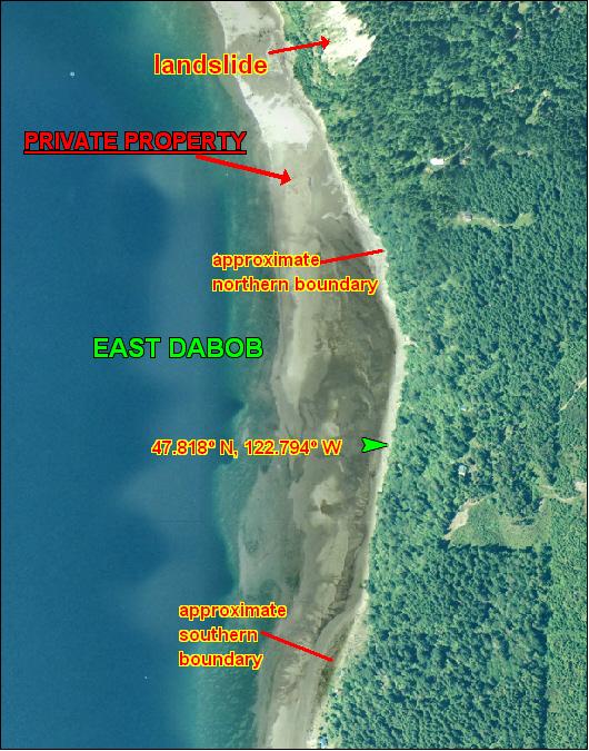
The boundaries for East Dabob are not well marked (see beach map). The beach is about a half mile from boundary to boundary. The north end starts about 350 yards south of a large landslide and the south boundary is just north of the first house to the south. There is also a ravine just north of the houses located near the southern boundary . When in doubt please stay well within these landmarks to avoid trespassing. Approximate GPS coordinates to the middle of the beach are: 47.818° N, 122.794° W. Take care when approaching the beach by boat. Shallow tide flats run a long distance off shore before they drop off into deep water.
There are no facilities at East Dabob.
There is plenty of beach for walking and wildlife viewing.