WDFW Beach Season Information
Clam and mussel seasons OPEN for harvest July 15 through September 30, 2024.
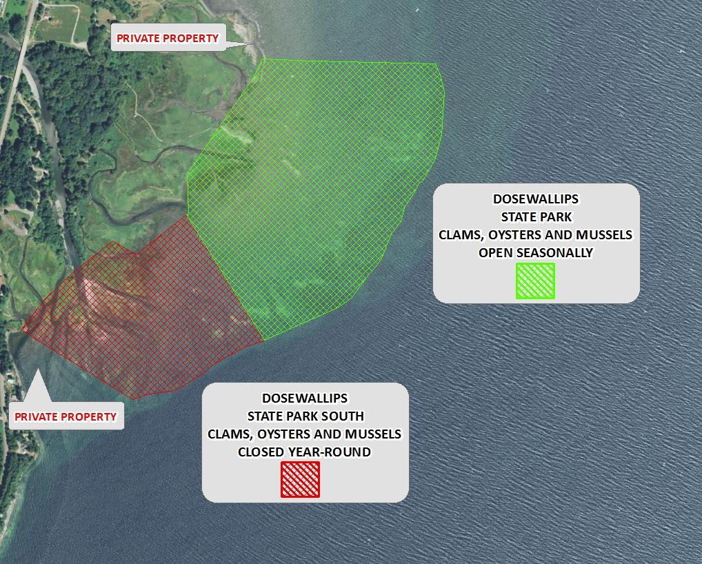
Oyster season OPEN for harvest year-round.
Other good clamming beaches nearby include Quilcene Bay WDFW Tidelands (open year-round), and Duckabush (open November 1 through April 30). You can search for many more using the Find a Beach tool.
Dosewallips State Park South is CLOSED year-round, south of the line defined by boundary markers on the beach.
Washington Department of Health (DOH) cautions that clams, oysters and mussels from this section of the beach are not fit for human consumption at any time (see Beach map below).
WDFW shellfish seasons indicate the specific times of year when harvesting is permitted. Before heading to the beach, please also check the Department of Health (DOH) information below which is related to health of the shellfish and may be updated daily. To harvest on this beach, it must be both during the WDFW approved season and approved by the DOH.
This is an excellent beach for Manila littleneck clams. The best areas are in the mid-upper tidal zone in mixed sand and gravel substrate. Productive digging is also found around and among the oysters, an area often overlooked by harvesters. Please take care not to cover oysters with sand and mud while digging clams because this will potentially kill the oysters. Native littleneck clams are available in the same areas as the Manila clams. Butter clams, cockles and horse clams can be found in the sandy areas below the oysters. This is a very popular beach for geoducks, which may be found in the low intertidal zone below minus two feet.
This is an excellent beach for oysters.
The flat trail from the parking lot to the beach is suitable for access by wheelchair, although there are areas of sticky mud on the beach that may make traversing the beach challenging.
From the south (Shelton and Olympia) travel north on Highway 101 to Brinnon. Day parking and access to the beach are reached by taking the first right after you cross the Dosewallips River. The beach access parking area is just north of the camp ground and the beach access trail head is located in the southeast corner of the parking area. The parking area is marked on the highway.
From the north (Kitsap County, Port Townsend, Port Angeles) travel south on Highway 101 to Brinnon. Day parking and access to the beach are reached by taking the last left before the Dosewallips River bridge. The beach access parking area is just south of the Brinnon Store and the beach access trail head is located in the south east corner of the parking area. The parking area is marked on the highway.
A Discover Pass is required to park at Dosewallips State Park.
Dosewallips State Park has restrooms, showers, potable water, year-round camping, and picnic areas. There are informational displays at the beach trail head. This beach has lots to offer bird watchers, hikers and naturalists. There is an observation platform on the beach trail that affords an excellent view of the tide flats, Hood Canal and the Olympic Mountains. Many types of birds, marine mammals and other wildlife can be seen from the platform. There is a convenience store and two cafés a short distance away from Dosewallips State Park.