WDFW Beach Season Information
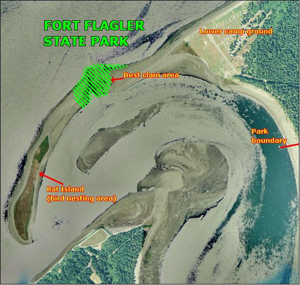
Rat Island is closed to public access from April 15 to August 31 in order to protect wildlife habitat. WDFW is working to reduce disturbance to shorebirds and seals that nest and pup on the island by limiting public access during the breeding season. The spit off Fort Flagler State Park is open for access.
Clam, mussel, and oyster seasons OPEN for harvest January 1 through April 15, 2025.
CLOSED for shellfish harvest April 16 to June 30, 2025.
Clam, mussel, and oyster seasons REOPEN for harvest July 1 through December 31, 2025.
Rat Island and the spit west and south of the park boundary is CLOSED for harvest year-round from two white posts on the north end of the island at the vegetation line south to the end of the island. While some people access it on foot at low tide, we ask that you not do so because Rat Island is a wildlife preserve. Please take care not to disturb birds or seals that may be present there. (See Beach Map)
WDFW shellfish seasons indicate the specific times of year when harvesting is permitted. Before heading to the beach, please also check the Department of Health (DOH) information below which is related to health of the shellfish and may be updated daily. To harvest on this beach, it must be both during the WDFW approved season and approved by the DOH.
Most of the clam resource at Fort Flagler State Park is located on the spit that runs southwest from the park (see beach map). This is an excellent beach for butter clams. The best areas are on the Port Townsend Bay (north) side of the spit, in and around the tidal channel that separates the spit from Rat Island. These are also good places for large native littleneck clams and horse clams. There are pockets of Manila clams in the mid-high tidal zone near the boat ramp in Kilisut Harbor. Varnish clams and eastern softshell clams are found at Fort Flagler State Park near the boat ramp, along the south side of the spit. Geoducks are also found on this beach below the -2.0 foot tide level, although digging for geoduck in the rocky substrate is very challenging. By law, all holes created while digging for clams must be filled in. Beach terrain must be returned to its original condition by clam diggers before leaving the beach.
There are some oysters at Fort Flagler State Park, but they are not abundant.
To reach the site from the west on Highway 104 take the Chimacum/Port Townsend/Quilcene exit and turn left onto Center Road. Travel north for about 10 miles to Chimacum. Go straight through the four-way stop and continue about two miles to Port Hadlock. Turn right onto Oak Bay Road and proceed for one mile to Flagler Road. There is a sign at this intersection for Fort Flagler State Park. Take a left onto Flagler Road and continue across the Indian Island bridge. Proceed about seven miles to Fort Flagler. After you enter the park, take the first left that leads through the park's check-in station to the lower campground, boat ramp and parking area for the beach.
To reach the site from the east on Highway 104 from the Hood Canal Bridge take the Port Townsend/Port Ludlow exit (a right turn) and travel north on Beaver Valley Road (Highway 19) for about seven miles to Chimacum. Take a right at the four-way stop and continue about two miles to Port Hadlock. Turn right at the four-way stop onto Oak Bay Road and proceed for one mile to Flagler Road. There is a sign at this intersection for Fort Flagler State Park. Take a left onto Flagler Road and continue across the Indian Island bridge for about seven miles to Fort Flagler. After you enter the park, take the first left that leads through the park's check-in station to the lower campground, boat ramp and parking area for the beach.
A Discover Pass is required to park at Fort Flagler State Park.
Fort Flagler State Park offers camping, a military museum, two boat ramps, a concession stand (summer only), restrooms/showers, hiking trails, water and a dock. Popular activities include kite flying and biking.
Historically Rat Island was a spit attached to the point on Marrowstone Island, near the lower campground. The spit was breached in the 1940s when boats were dragged across it during military exercises. Since then, a combination of currents and sediment transport interruption caused by the north shore boat ramp have kept Rat Island cut off from Marrowstone Island except during very low tides. At one time this spit enclosed what was historically an approximately 22-acre salt marsh where the lower campground now sits.