WDFW Beach Season Information
Clam, mussel, and oyster seasons OPEN April 1 through May 31, 2025.
Other good oyster beaches nearby include WDFW Hoodsport Hatchery (open April 1 through June 30) and Eagle Creek (oysters open year-round).
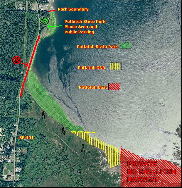
Potlatch State Park and Potlatch DNR are adjacent public beaches owned by two different state agencies. Shellfish seasons and regulations are identical for both beaches.
The ONLY land access to the public beach at Potlatch State Park and Potlatch DNR is through the Park’s main parking lot. Parking is PROHIBITED at all times along the Highway 101 shoulder between milepost 335.07 (entrance to Potlatch State Park) and south to milepost 335.72 (northbound slow vehicle turnout). Property east of Potlatch DNR is privately owned. Trespassing and parking restrictions are being enforced.
WDFW shellfish seasons indicate the specific times of year when harvesting is permitted. Before heading to the beach, please also check the Department of Health (DOH) information below which is related to health of the shellfish and may be updated daily. To harvest on this beach, it must be both during the WDFW approved season and approved by the DOH.
Please take care not to cover oysters with sand and mud while digging clams because this will potentially kill the oysters. Potlatch State Park has over a mile of tidelands, but some areas provide better digging for different species. The stretch of beach that is closest to the highway is regularly harvested by recreational diggers, and good numbers of Manila clams can be found here. Manila clams can be found throughout the middle and upper intertidal zones, with greatest abundance on the large tide flat at the southern end of Annas Bay where the park’s shoreline turns easterly. Native littleneck clams are present throughout the beach, but in lower abundance and usually lower in tidal elevation than Manila clams. The best digging for butter clams is in front of the main parking area in the lower intertidal zone. Butter clams are also common in the lower intertidal zone throughout the south end of the beach. Varnish clams are found in great abundance all along the southern shoreline of Potlatch State Park and Potlatch DNR, usually in the upper intertidal zone. Eastern softshell clams can be found at Potlatch State Park, particularly in areas with freshwater influence from Enetai Creek (also the site of the Skokomish Fisheries Department fish trap).
Potlatch DNR is a good beach for butter clams. The best digging is in the middle intertidal zone in sand and mixed sand/gravel. There are some good spots for Manila and native littleneck clams in the middle and upper intertidal zones. Eastern softshell and Varnish clams are also found at Potlatch DNR, usually in the middle and upper intertidal zones.
Potlatch State Park is an excellent beach for oysters. There are extensive oyster beds in the stretch of beach near the highway, as well as north and east of Enetai Creek. Potlatch DNR is a good beach for oysters, but they are more abundant at Potlatch State Park.
Tidelands to the east of the Potlatch DNR boundary are owned by The Skokomish Tribal Nation. Non-consumptive recreational use is permitted. All shellfish harvest is strictly prohibited on these tidelands. (See Beach Map)

From the south (Shelton and Olympia) travel north on Highway 101 through Shelton and continue for about 12 miles. Look for the state park signs and entrance on the right hand side of the road just after Highway 101 reaches the shore of Hood Canal.
From the east on Highway 3 (Bremerton, Belfair) or the south on Highway 16 (Tacoma) take Highway 3 to Belfair. Continue south through Belfair and take the Highway 106 exit (a right turn) and continue for about 22 miles to the intersection of Highway 101 and Highway 106. Turn right on Highway 101 and proceed for another three miles to Potaltch State Park. The park entrance is on the right and is well marked on the highway.
From the north on Highway 101 (Quilcene, Port Angeles) travel south through the town of Hoodsport and continue for about another two and a half miles to Potlatch State Park. The park entrance is on the left and is well marked on the highway.
Potlatch DNR is adjacent to, and just east of Potlatch State Park. A line of carsonite (fiberglass) posts marks the boundary between the two beaches. Access to Potlatch DNR is via the main parking area at Potlatch State Park. Potlatch DNR is about three quarters of a mile southeast of the parking area at Potlatch State Park.
Trespassing and parking restrictions are being enforced. The ONLY land access to the public beach at Potlatch State Park and Potlatch DNR is now through the Park's main parking lot.
Parking is PROHIBITED at all times along the shoulder between milepost 335.07 (entrance to Potlatch State Park) and south to milepost 335.72 (approximately where Hood Canal is no longer visible from Highway 101). Also, the strip of land between the highway turnout and the public beach is privately owned; there is no longer ANY access to the public beach from the highway turnout.
Potlatch State Park has restrooms, showers, potable water, camping and picnic areas. There are no facilities at Potlatch DNR.