WDFW Beach Season Information
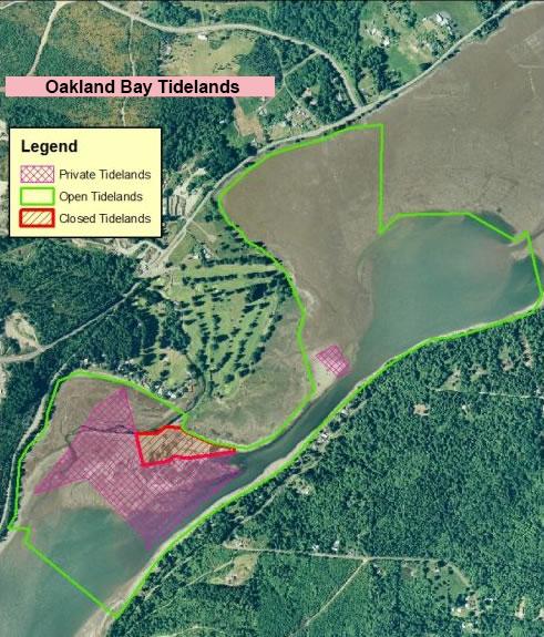
Clam, mussel, and oyster seasons OPEN for harvest year-round, except area defined by boundary markers and signs is closed year-round to clam and oyster harvest (see map below)
WDFW shellfish seasons indicate the specific times of year when harvesting is permitted. Before heading to the beach, please also check the Department of Health (DOH) information below which is related to health of the shellfish and may be updated daily. To harvest on this beach, it must be both during the WDFW approved season and approved by the DOH.
This beach does not require a very low tide to access good clamming habitat. A plus 2-foot tide or lower will expose enough of the beach to harvest clams. Abundant Manila clams live in the mixed gravel and mud. They can be easily harvested at higher tide heights and there is no need to venture into the sticky black mud in the low intertidal zone. Digging clams on this beach can be a very dirty job because of the soft sticky mud. Try the southeast portion of the beach that borders the main tidal channel. Manila clams are very abundant here and the substrate is not quite as muddy (see beach map). Eastern softshell clams are also available on this beach.
This is a good beach for oysters.
From Olympia, follow Highway 3 through Shelton then north to the public access just northeast of the Bayshore Golf Club. Watch for a "Public Fishing" sign at the entrance to the parking lot.
From Highway 101 (coming from either the north or south), take the Wallace-Kneeland Blvd. exit, and follow Wallace-Kneeland Blvd. (which turns into Johns Prairie Rd. and then joins Highway 3) about 5.7 miles to the WDFW public access parking lot, located on the right side of Highway 3 just northeast of the Bayshore Golf Club.
From Bremerton, follow Highway 3 south towards Shelton, and look for the public access parking lot on the left, shortly after passing Mason Lake Rd.
A short trail bordering the Bayshore Golf Course leads from the parking lot to the beach. Clamming is good from here southward along the beach until you reach the concrete walls of the old Olympia oyster dikes. WDFW signs and posts mark the boundary of private & closed areas beginning at this point. On the south side of the Bayshore Peninsula (golf course) public tidelands surround plots of private tidelands and closed areas (see beach map).
Except for the access trail, parking lot and public tidelands all of the uplands surrounding the golf course are private property. There is also a plot of private tidelands adjacent to the public tidelands. It is located north of the public tidelands at about the halfway point of Oakland Bay Recreation Tidelands. The boundaries of this area are marked by fiberglass posts and concrete blocks (see beach map). Please stay off the uplands and well away from private tidelands to avoid trespassing.
Portable toilets are located on site.