WDFW Beach Season Information
Clam, mussel, and oyster seasons OPEN for harvest year-round.
WDFW shellfish seasons indicate the specific times of year when harvesting is permitted. Before heading to the beach, please also check the Department of Health (DOH) information below which is related to health of the shellfish and may be updated daily. To harvest on this beach, it must be both during the WDFW approved season and approved by the DOH.
Pacific oysters, eastern softshell, Manilas and cockles can be found here.
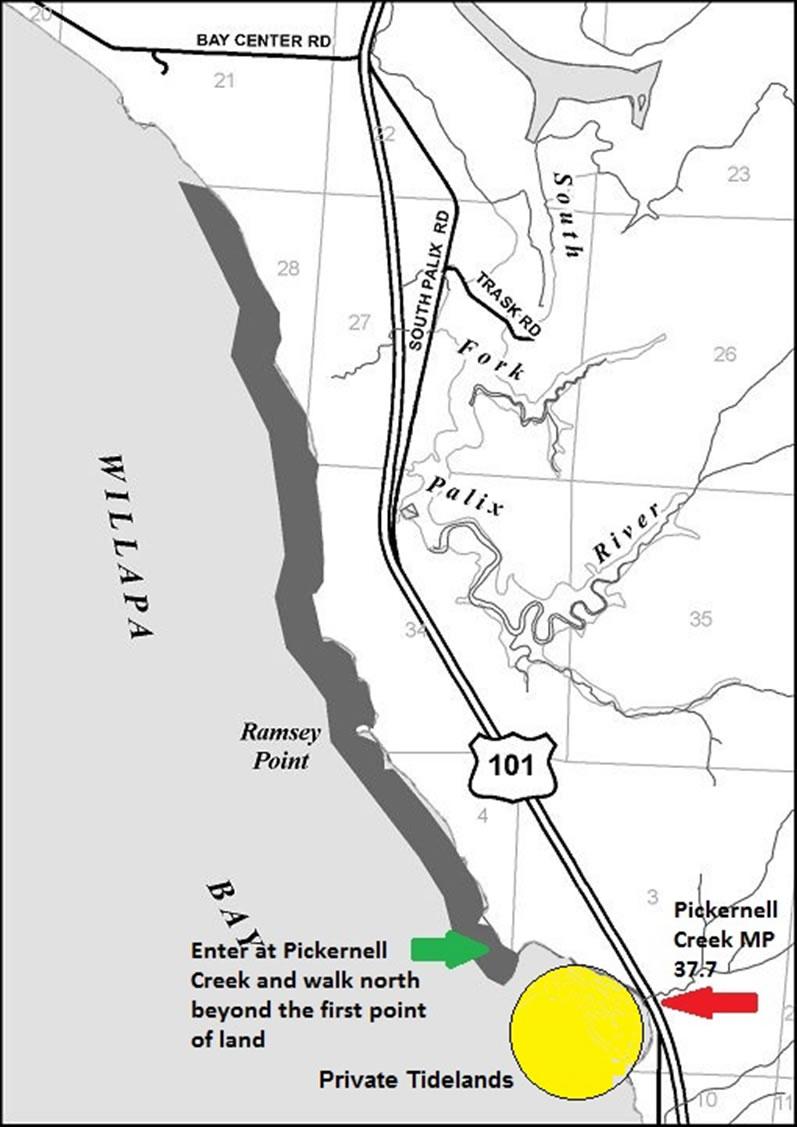
Driving directions: From Raymond/South Bend, follow US 101 south towards Long Beach to Pickernell Creek (at milepost 37.7)
Access:The Nemah site may be accessed by boat or by land at Pickernell Creek off Highway 101. The gravel turnout on the west side of Highway 101 just south of Pickernell Creek (at milepost 37.7) may be used for parking.Harvesters access the beach area from the north side of Pickernell Creek.Once on the beach you will see a point of land about 1/4 mile north.You are asked to walk beyond this first point before clamming to avoid any trespassing conflicts with nearby private clam ground.Once you reach this point of land the whole area to the north is open for public harvest.
Location: Second class tidelands lying in front of, adjacent to, or abutting upon Government Lots 5, 6, and 7, Section 3, and Government Lots 1, 2, and 3, Section 4 Township 12 north, Range 10 west, W.M.: Government Lots 1, 2, 3, and 4, Section 34, Section 27, and Lots 1, 2, 3, and 4 Section 28, Township 13 north Range 10 west, W.M. lying easterly of the Nemah Oyster Reserve and easterly of privately owned tidelands tracts. The southern boundary of this public tideland area starts north of Pickernell Creek and continues north approximately 3-1/2 miles.
Boundaries: From mean high water west to the eastern boundary of private tidelands tracts and the Nemah Oyster Reserve. Be aware that some private tideland boundaries fall very close to the shoreline, especially near the southern boundary of these public tidelands. The area directly in front of the gravel turnout is private land.In this area the adjacent landowner has only marked portions of their privately owned shellfish bed with white plastic stakes. Private tidelands are found on both sides of Pickernell Creek. Please respect private property and avoid harvesting in this area.
No camping allowed at this site.
There are no sanitary facilities provided at or near this site. Think ahead.
Nearest boat launch is located at Palix River or Bay Center.
For additional information call WDFW Region 6 headquarters (360) 249-4628 or Pacific County Department of Community Development (360) 875-9356.