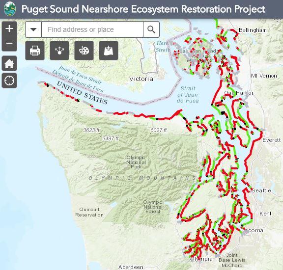
The Puget Sound Nearshore Ecosystem Restoration Project (PSNERP) has identified process units that make up the Puget Sound's shoreline drift cells the adjacent upland watershed areas.
This web accessible map of spatial nearshore data can be used to access the Shoreline Process Units (SPUs), Delta Process Units (DPUs), and associated summary reports.
Additional mapping resources
Washington State Coastal Atlas
Provides coastal information (maps, shoreline pictures, beach access and closure information) for resource planning and management.
Washington State ShoreZone Inventory
Describes physical and biological characteristics of intertidal and shallow subtidal areas along Washington's saltwater shorelines.
Puget Sound River History Project
Study of the historical landscape of Puget Sound's lowland rivers and estuaries. Website includes historical Puget Sound T-sheets; shoreline maps that were created in the late 1800 to early 1900s. The T-Sheets contain information such as locations of buildings, names of shoreline features, and detailed descriptions of shorelines.
Story maps
Feeder Bluffs and Coastal Landforms
This story map developed by Washington Department of Ecology explains and illustrates the various coastal landforms that make up the Puget Sound shoreline.
Snohomish salmon
Salmon populations in Puget Sound have decreased due to a variety of factors. Habitat restoration can increase these numbers, and one of the most important habitat types to restore is the estuary, where freshwater and saltwater meet. Check out the story map to learn why estuaries are so important to salmon and more about the work being done in the Snohomish River estuary to help increase populations.
Farm, fish, and flood
The goal of the farm, fish, and flood story map is to encourage a growing spirit of collaboration and work toward a common vision for the Snohomish delta. The story map is intended to showcase multiple benefits of focusing on farms, fish, and flood protection in an integrated way across the landscape.
Investing in Puget Sound's natural systems
This story map illustrates the benefits to investing in Puget Sound estuaries, such as local jobs, community protection, and economic benefits. It also highlights the integral role estuaries play in our nearshore ecosystem.
Working together to restore Puget Sound ecosystems
This photo slider map highlights nearshore restoration and protection projects funded by the ESRP throughout Puget Sound. Together with restoration partners, these projects are key to restoring Puget Sound's estuaries, bays, and shorelines, creating the foundation for a resilient Puget Sound.