The skipper of each vessel landing Dungeness crab in Washington is responsible for maintaining a logbook provided by the Washington Department of Fish and Wildlife (WDFW) in accordance with these instructions (WAC 220-340-460). Vessel operators must complete a logbook entry for each day fished prior to offloading.
Logbooks are due by the 10th of each month for the previous month. Send completed logbooks to:
WDFW Attn: Coastal Crab Manager
48 Devonshire Rd.
Montesano, WA 98563
- Vessel: Registered name of vessel
- Crab License #: Coastal Dungeness crab license number
- Port: Port of landing
- Federal #: Vessel’s Federal document number
- Landing date: Date of landing (on fish ticket)
- Fish Ticket #: Fish ticket number
Logbook information instructions
- Date: Date the pot or string is picked
- String #: A random numeric identifier for strings (example: 1, 2, 3, etc.)
- Depth (fm): Average depth of the string
- Pots Fished: Number of pots currently being fished in string
- Pots Lost: Number of pots that are unlikely to be retrieved due to weather or disappearance of pot
- Soak Time (days): Number of days a pot has been fishing (example: 2.5 days)
-
- Longitude Begin/End: Longitude of the beginning and end of the string
- Number of Crab Retained: Number of individual crab retained in each string of pots
- Logbook Catch Area: Catch area of string using catch areas on front cover of Coastal Dungeness Crab Fishery Logbook
- Lost Gear Recovered: Number of pots recovered that were previously considered lost and recorded in Pots Lost column of logbook
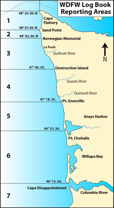
Logbook reporting areas
The following catch areas are used in logbook reporting:
Catch area 1: U.S. Border - 48°07.00 (Sand Point)
Catch area 2: 48°07.00 - 48°02.00 (Norwegian Memorial)
Catch area 3: 48°02.00 - 47°40.50 (Destruction Island)
Catch area 4: 47°40.50 - 47°18.35 (Point Grenville)
Catch area 5: 47°18.35 - 46°53.30 (Point Chehalis)
Catch area 6: 46°53.30 - 46°15.00 (WA/OR border)
Catch area 7: South of 46°15.00 (Oregon)