These maps are for general purpose use only.
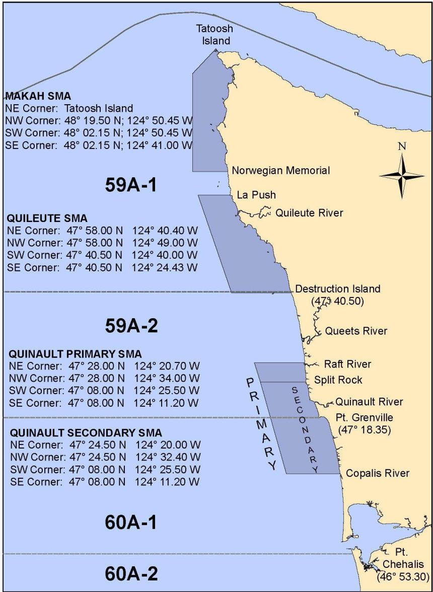
2025 Quinault Special Management Area

The Quinault secondary SMA (SSMA) will be closed to state fishers beginning at 8 a.m. on March 21, 2025. The secondary SMA is scheduled to remain closed to state fishers until further notice. The Quinault SSMA is defined by the following coordinates:
- Northeast Corner (Split Rock): 47° 24.50’ N. Lat. 124° 20.00’ W. Lon.
- Northwest Corner: 47° 24.50’ N. Lat. 124° 28.50’ W. Lon
- Southwest Corner: 47° 12.25’ N. Lat. 124° 19.00’ W. Lon.
- Southeast Corner (Joe Creek): 47° 12.25’ N. Lat. 124° 12.28’ W. Lon.
A portion of the Quinault SMA will open to state fishers beginning at 8 a.m. on March 21, 2025. A 100-pot limit will be in effect in this area until 8 a.m. on April 21, 2025. The area opening to state fishers (shown in yellow on map above) is defined by the following coordinates:
- Raft River (East): 47° 28.00’ N. Lat. 124° 20.70’ W. Lon.
- Raft River (West): 47° 28.00’ N. Lat. 124° 34.00’ W. Lon.
- Split Rock (East): 47° 24.50’ N. Lat. 124° 20.00’ W. Lon.
- Split Rock (West): 47° 24.50’ N. Lat. 124° 28.50’ W. Lon.
- Joe Creek (East): 47° 12.25’ N. Lat. 124° 12.28’ W. Lon.
- Joe Creek (West): 47° 12.25’ N. Lat. 124° 19.00’ W. Lon.
- Copalis River (East): 47° 08.00’ N. Lat. 124° 11.20’ W. Lon.
- Copalis River (West): 47° 08.00’ N. Lat. 124° 25.50’ W. Lon.
2024-25 Coastal Dungeness Crab Season Fair Start Structure

Area 1: Klipsan Beach (46°28.00 N) to Cape Falcon, OR (including Willapa Bay)
Opens at 9 a.m. on January 15, 2025, with gear setting at 8 a.m. on January 12, 2025.
Licenses and vessels designated to those licenses that fish in the fishery between Pt. Arena, CA and Cape Falcon, OR, before the area between Cape Falcon, OR and Klipsan Beach opens will be allowed to fish in Area 1 at 8 a.m. on February 14, 2025.
Area 2: Oysterville (46°33.00 N) to Klipsan Beach (46°28.00 N)
Opens at 9 a.m. on February 11, 2025, with gear setting at 8 a.m. on February 8, 2025.
Licenses and vessels designated to those licenses that fish in the fishery between Pt. Arena, CA and Klipsan Beach, WA, including Willapa Bay, before the area north of Klipsan Beach opens will be allowed to fish in Area 2 at 8 a.m. on February 21, 2025.
Areas 3-5: Oysterville (46°33.00 N) to US/Canada border
Opens at 9 a.m. February 11, 2025, with gear setting at 8 a.m. on February 8, 2025.
Licenses and vessels designated to those licenses that fish in the fishery between Pt. Arena, CA and Klipsan Beach, WA, including Willapa Bay (Area 1), before the area north of Klipsan Beach opens will be allowed to fish in Areas 3-5 at 8 a.m. on March 18, 2025.
WAC 220-340-400 Definition - Commercial crab fishing: "Commercial crab fishing" means any taking, fishing, use, or operation of gear to fish for crab for commercial purposes and includes the possession of crab on the water for commercial purposes, and the landing or initial delivery of crab for commercial purposes.
Coastal Dungeness Crab Season Special Management Area (SMA) Restrictions
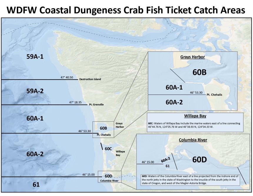
Commercial Crab Fishing WDFW Catch Reporting Areas