
The PHS on the Web app allows you to navigate to your project area and create a PHS report with nearby priority habitats and species. The instructions below walk you through the most common uses.
Contact
Your local habitat biologist can provide site-specific advice. Please contact PHS customer service staff to fulfill requests for custom maps (PDF) at 360-902-2543.
Create PHS report for a parcel
Scenario: The owner of a vacant parcel on Wagner Lake wants to know what priority habitats and priority species are found on their land.
- Navigate to the neighborhood.
- Click parcel select tool, leaving buffer distance blank, and click the parcel.
- The parcel is outlined in red. PHS records that intersect or lie within the parcel are outlined in blue.
- You’ll notice a pink point (Western toad location) that was not selected because it was outside the red-outlined parcel.
Photo by WDFWImage
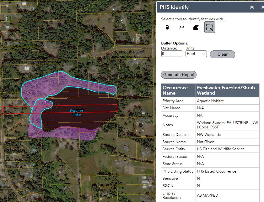
The parcel is outlined in red with relevant PHS records in blue.
- Use the scroll bar to read the attributes of the selected PHS record: a palustrine wetland.
- Make a PHS report. Zoom in until your project fills the screen. Click Generate Report to create a pdf that contains:
- Map with subject parcel and buffers.
- User comments/notes.
- Listed species (federal or state) or sensitive species whose exact location cannot be shown.
- Details of species and habitats selected.
- Rerun report every six months because PHS records are constantly updated.
Create PHS report for a buffered parcel
Scenario: The owner of a vacant parcel on Wagner Lake wants to build a home. The county’s Critical Areas Ordinance requires that they identify and protect all priority habitats and priority species within 150 feet of the project boundaries.
- Navigate to the neighborhood.
- Enter “150” in the Distance box and select “Feet” from the Units dropdown. Click parcel select tool, then click the parcel.
- The selected parcel is outlined in red with a 150-foot buffer shown by a dashed red line. PHS records are outlined in blue.
- In this case, the pink point north of the parcel is outlined in blue because it is within the 150-foot parcel buffer. The PHS point (Western toad) is shown in the attribute table.
Photo by WDFWImage
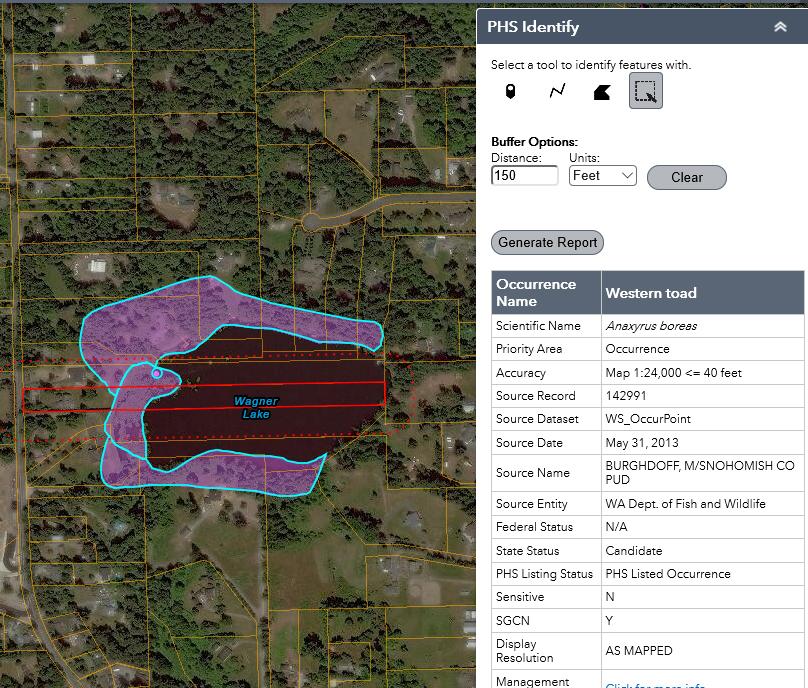
The parcel is outlined in red with relevant PHS records in blue, including the Western toad point.
- Click the bookmarks button, enter a name (Wagner Lake), and save to easily return to the map.
- Results. The project site is near a surveyed point of Western toad, a state candidate species. The county’s Critical Areas Ordinance and planning department confirm the landowner must hire a professional biologist to prepare a Habitat Management Plan. A home can be built but may require steps to avoid and minimize impacts and on-site or off-site mitigation for unavoidable habitat loss (GMA no net loss standard).
- Make a PHS report. Zoom in until your project fills the screen. Click Generate Report to create a pdf that contains:
- Map with subject parcel and buffers.
- User comments/notes.
- Listed species (federal or state) or sensitive species whose exact location cannot be shown.
- Details of species and habitats selected.
- Rerun report every six months because PHS records are constantly updated.
Find a mitigation site
Scenario: The owner of a vacant parcel on Wagner Lake wants to build a home. They learned of a nearby Western toad site and hired a professional biologist to complete a county-required Habitat Management Plan. After modifying the building footprint, there was still an unavoidable impact to 2,000 square feet of Western toad habitat. This impact requires mitigation, but there are no suitable mitigation opportunities on Wagner Lake. The landowners need to find nearby Western toad habitat to protect or enhance.
- Navigate to the neighborhood or use the bookmark tool to select Wagner Lake bookmark from the last exercise.
- Open the attribute table by clicking the up arrow at the bottom of the map.
- In the PHS Points tab, confirm Filter by map extent is selected. The table shows one record: Western toad near their parcel. Click the far-left side of the record to select it.
- Still on the PHS Points tab, click Options, then Filter.
- In the first box, select Occurrence_Name (String).
- In the second box select is.
- In the third box, click the cog, select Unique, then click on the third box’s dropdown and select Western toad. Click OK to apply the filter.
Photo by WDFWImage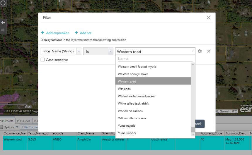
Filter data to show nearby Western toad locations. - In the map window, click Zoom out until the scale bar reads “3 mi.” Four records appear in the Attribute table. Select all four records to view in the map.
Photo by WDFWImage
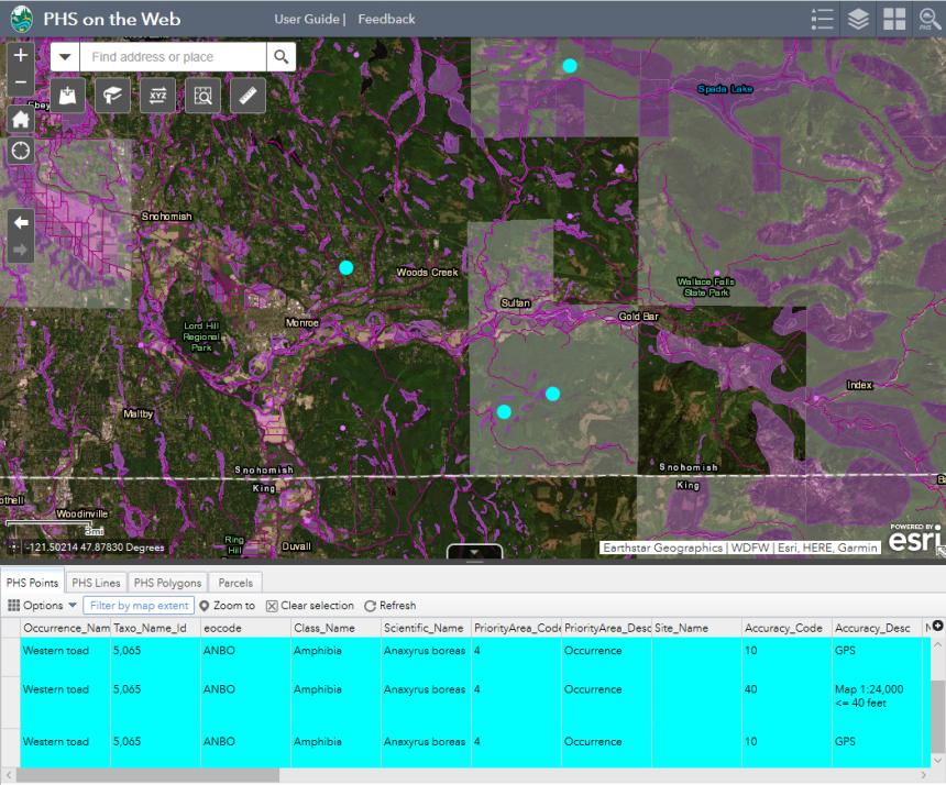
Zoom out to see four nearby Western toad locations. - Identify landowners of Western toad habitat:
- Click Clear selection button.
- Select first record and click Zoom to button.
- Click inside the parcel with the Western toad record.
- A popup box indicates two records. Click the right arrow to move to the second record with parcel info.
- Click the More info hyperlink to access county assessor details such as parcel owner and contact information.
Photo by WDFWImage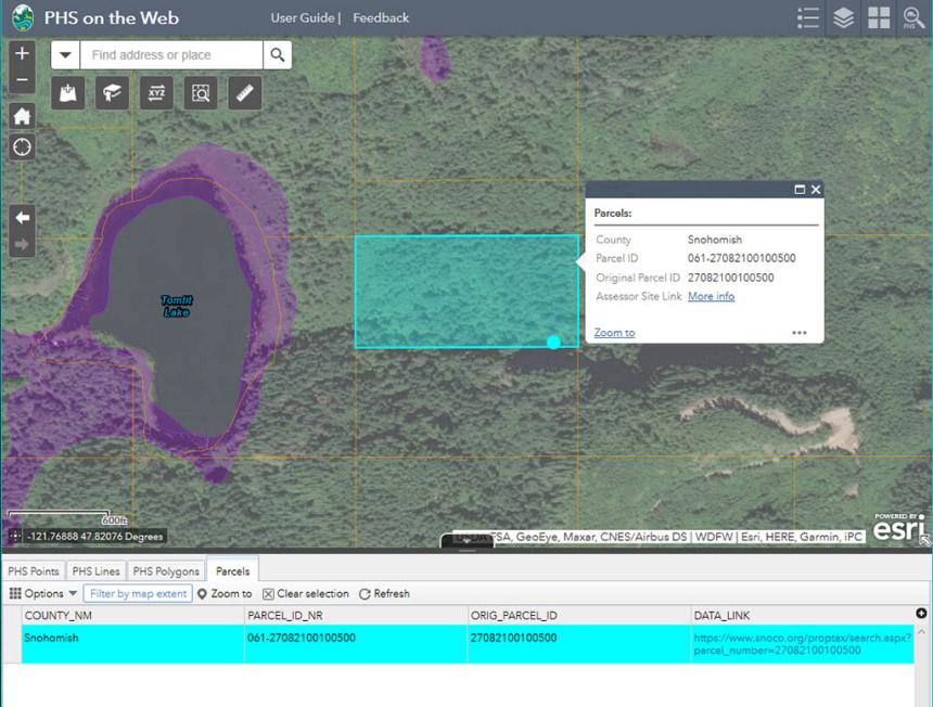
Identify landowners of Western toad habitat.
The landowner completed this process for all four parcels with Western toad points and contacted them. An agreement was reached with a land trust to permanently preserve 6,000 square feet of Western toad habitat (the Critical Areas Ordinance required a 3:1 ratio for off-site mitigation). With mitigation requirements met, the landowner built their home and made their county a better place for Western toads.