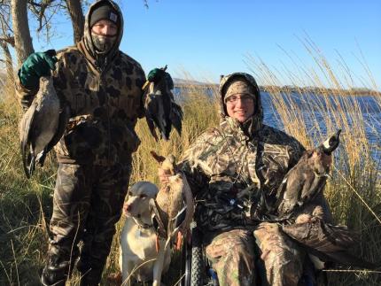
There are a number of Americans with Disabilities Act (ADA) designated hunting and wildlife-viewing blinds and platforms throughout Washington that are accessible to people with disabilities.
General information
All hunters without disabilities should yield ADA hunting/wildlife viewing blinds and platforms to a hunter with a disability if the blind was reserved in advance. They should also yield or be willing to share it if a hunter with a disability is there at least 1 1/2 hours prior to daylight.
Anyone with WDFW Disability Status and issued a DOL disabled license plate or blue parking placard for an ambulation disability has preference over hunters without disabilities at ADA blinds.
Access for hunting has preference over wildlife viewing during the waterfowl hunting seasons.
ADA blinds and platforms that are not reserved in advance with a land manager, or where applicable the Private Lands Hunting Access program, should be occupied at least 1 1/2 hours prior to daylight.
Most of the duck and goose blinds are custom-made of fiberglass, wood, or aluminum. They are a minimum of 5 feet deep and 7 feet wide, with a lower front made to shoot over when seated, and a roof over the back half that protects the user from foul weather. Some blinds or goose pits are made of wood and were built on-site. All blinds are located on a compacted gravel path or have a vehicle drop-off or parking area nearby, and all are designed to be wheelchair accessible. Conditions and maintenance in the outdoor environment changes from year-to-year, so be prepared for a challenge.
Typically these blinds will comfortably accommodate one person in a wheelchair and two other people, a dog, and hunting gear; or, two wheelchairs and one person with gear and a dog. The wooden ground-level goose pits have ramps down into them. Most blinds are installed permanently on the site, but some are moved in and out each year due to flooding.
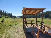
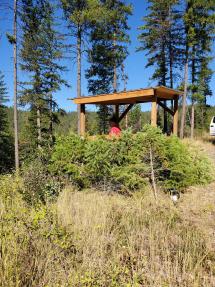
ADA hunting and wildlife viewing platforms are constructed (either by Inland Northwest Wildlife Council members or groups they coordinate with) of wood with a minor grade to be safe for wheelchair users and have covers built over the top to protect users from weather. Most platforms can accommodate at least one wheelchair, one or two extra people, and gear.
Report any major damage or vandalism of the blinds to WDFW at 360-902-2936.
Always check the hunting regulations and rules for the area you are hunting; federal area rules may differ.
Eastern Washington (Region 1)
Sherman Creek Wildlife Area
There are three platforms ADA hunting and wildlife viewing platforms in the Sherman Creek Wildlife Area, with two on the Rustlers Gulch unit of the wildlife area. Access is granted through the wildlife area manager by calling 509-738-4120.
- Head North out of Spokane on US 395 to Kettle Falls.
- Continue across the Columbia River and stay left on SR 20 until the intersection with Highway 3; Inchelium Republic Road.
- Turn left and continue until there is an Apple Orchard on the left. The next left will be an unmarked road that will lead to a small parking area. Proceed through the gap in the large berm, which is designed to keep vehicles out, but still allow foot traffic as well as wheelchairs.
- Approximately ¼ mile past the berm, you will come to the platform, situated on the left side of the road with shooting lanes to the left into the open field, or ahead and to the right into a wooded area.
GPS coordinates: 48.57272 -118.15173
Rustlers Gulch Wildlife Area Unit
Location 1 Driving directions:
- From the intersection of US 2 and Deer Park - Milan Road (a.k.a. Riverside), travel North 7.5 miles, then turn left onto Fertile Valley Road.
- Continue on Fertile Valley Road for 2.5 miles.
- Look for the sign for Roberts Road on the right. To the left of that, there will be three different roads, all next to each other. Take the third left onto Last Chance Road.
- In approximately 1.2 miles there will be a wide shoulder/parking area on the left and the gate will be directly ahead.
- After passing through the gate, you will find the platform after an additional 1.2 miles, on the left.
GPS coordinates: 48.10016 -117.40441
Location 2 Driving directions:
- Travelling north on US 2 from Spokane, take a left on East Eloika Lake Road (also known as East West Branch Road).
- Continue along the road, then go right onto North Division Rd. This road will bend to the left, then to the right and eventually turn to gravel as it becomes Horseshoe Lake Road.
- Continue to where the road split in two. There will be a gravel parking area across the intersection. Directly the right is a gate. Use the combination provided by WDFW staff, then lock the gate after entering.
- Continue down the hill to the right. At the bottom is a gravel path. Follow it across the culvert, up and around the bend to the left and the platform will be on the right before you reach the barn.
GPS coordinates: 48.07132 -117.41842
Colville National Forest
There are six platforms located in the Colville National Forest. Potential users must apply for access through the forest at their Three Rivers Ranger Station at 255 W. 11th Ave., Kettle Falls, WA.
Location 1, Brewer Mountain, driving directions:
- From Spokane take US 395 North to Chewelah. On the North end of town, turn right onto Sand Canyon Road. Stay on Sand Canyon Road past the golf course and small airport until the pavement ends and the road turns to gravel.
- Continue into the Colville National Forest. At that point the road becomes USFS 9521 Road. Travel past the first open meadow with a camping area. A second, larger open field area that is popular with campers is known as "The Meadows" on the map but there is not a sign on-site.
- Continue past The Meadows to the first left, with a faded marker that says “100.” Travel up the 100 Rd. to the first spur on the right, turn and approach the gate.
- After passing through the gate, continue, forward, staying right at the fork, until you reach the platform on your right.
GPS coordinates: 48.39257 -117.61754
Location 2, Squirrel Meadows (two platforms), driving directions:
- Take US 2 North from Spokane.
- Approximately one mile before Diamond Lake, turn left on Hwy. 211 towards Usk, Cusick, and Metaline Falls.
- Continue on Hwy. 211 past Sacheen Lake and Davis Lake until to the crossroads of Hwy. 211 and Hwy. 20. Turn left and continue north on Hwy. 20 past Cusick, Riverview Bible Camp, the Ruby Crossing Boat Launch and arrive near Blueslide. There will be a sign that says “Ruby Creek Road.”
- Turn Left, and drive up the road approximately one mile, turn left onto “Squirrel Road” and the gate is ahead.
Platform 1 location:
- After passing through the gate, stay right at first and second forks. Continue down and around bend to the left until the platform is on the right.
GPS coordinates: 48.5447 -117.35944
Platform 2 Location:
- After passing through the gate, stay on main route past the first and second fork, stay right at the third, and the platform will be on the left.
GPS coordinates: 48.53385 - 117.34398
Location 3, Aladdin Mountain (two platforms), driving directions:
- From Spokane, take Hwy. 2 North to the Jct. of Hwy. 211, north to Hwy. 20, left on Hwy. 20, and continue past Cusick, Usk, and toward Ione. Once you past the junction of Hwy. 20, and Hwy. 31 (Tiger), Hwy. 20 goes left (west) from there. Do not turn; continue North on Hwy. 31.
- Head north on Hwy. 31 for 2.1 miles toward Ione. Turn left on Greenhouse Rd. Travel West on Greenhouse Rd. for 0.9 miles, and turn right onto Honsinger Rd.
- Continue for 1.6 miles to Creek Side Rd. N and turn left. After 0.2 miles Creek Side Rd. bends to the right and becomes Birch Terrace Dr.
- Drive 0.1 miles on Birch Terrace, then stay left onto Bud Porter Rd., which immediately becomes the Smackout Pass Rd. (also known as County Road 2714).
- Stay on Smackout Pass Rd. for 2.1 miles, then turn left onto Meadow Creek Rd .(County Road 2695). Continue on Meadow Creek for 5.9 miles, past Big Meadow Lake, and turn left onto 200 Rd. and travel 2.1 miles to a sharp turn to the left.
- There will be a road that goes to the right and a gate. Stay right, enter the combination on the lock to enter, and close the gate behind you. This is 330 Rd. Continue up the road, around the north side of the mountain past two wheelchair platforms, both on the ride side of the road, until the road comes to an end.
GPS coordinates:
Platform #1: 48.73447 -117.60246
Platform #2: 48.73424 -117.62801
Location 4, Mitchell Mountain, driving directions:
This location is a Disabled hunter road access entry program site. Access is determined by a lottery system.
- After taking Sand Canyon Road out of Chewelah, continue into the Colville National Forest, then turn right onto Mitchell Mtn. Rd. (48.37363, -117.67043) and continue up the road, staying left at the first T in the road.
- The gate is located at 48.36101, -117.66624. After proceeding through the gate, continue to 48.36312, -117.64615 and turn left onto Spur Rd.
- Continue down the Spur to the T at 48.35556, -117.64517, and turn left. The road will descend along the side of the hill and then veer to the right. Look for a trail on the right that turns up the hill to an opening on a small bluff, just before the road turns back to the left. The platform is located at the edge of the bluff overlooking the drainage below.
GPS coordinates: 48.35717, -117.64342
McNary National Wildlife Refuge
Most blinds in the refuge are walk-in only, however, the accessible blinds can be approached by vehicle for easy unloading. The blinds are primarily for ducks, but may also offer some pass shooting for geese, which are plentiful in the area.
Two blinds, inside the boundaries of the refuge, are managed by the refuge through a new advance mail-in application reservation process For more information, see this handout (PDF).
Driving directions:
- Follow SR-12 east from Pasco for about 6 miles until you cross the Snake River bridge.
- Go past SR-124 (turn off to Walla Walla - Waitsburg), turn left on Maple Street and follow it to the Refuge Office.
Peninsula Habitat Management Unit
This blind is managed by the McNary Refuge and is located in the Peninsula Habitat Management Unit, on a back-water bay of the Columbia River. It has a gravel drop-off area within 25 feet of the blind. An old service road into the blind is closed off with a locked gate. Decoys can be put out while wearing chest waders. A duck boat can be put in the water nearby, or a dog can help with retrieval. Disabled Hunters should occupy the blind at least 2 1/2 hours before daylight because of the competition for blinds in this area. For more information, call the McNary Refuge in advance at 509-547-4942.
Disabled Hunters should occupy the blind at least 2 1/2 hours before daylight because of the competition for blinds in this area. Peninsula Habitat hunt information and application (PDF).
Driving directions:
- Follow SR-12 from Pasco until you cross the Snake River bridge, then take the first right turn on Hansen Loop Road. Follow this main road around a sharp left corner and drive for about 3 miles, passing through a little community and residential housing area, until you see the Peninsula Habitat Management Unit sign and registration booth on the right.
- Turn right on a primitive road and go down-hill across the railroad tracks to an old paved road.
- Turn left and follow the road to a locked gate.
- Go past the upland goose pits to where the paved road ends in the water.
- Stay right on the gravel road and go about one-third mile to the blind on the left. A four-wheel drive vehicle is not generally needed to get to the blind.
For more information, call the McNary Refuge in advance at 509-547-4942, and see this hunting guide (PDF) for additional information about USFWS hunting regulations.
North central Washington (Region 2)
Rocky Ford Creek
The duck blind is behind a locked gate on Rocky Ford Creek by an irrigation dam. The pond created by the dam provides a nice open-water area for ducks. It remains open a little longer in the winter because it has more flow than other areas. There is a gravel drop-off area beside the blind. Decoys can be put out while wearing chest waders, however, a small boat could be used if needed.
The half-mile primitive road from the locked gate to the blind is dirt, rock, and some gravel and should be useable by most vans and two-wheel drive trucks. A parking area by the gate is used mostly by walk-in hunters and fishers. A wheelchair accessible concrete vault toilet and an accessible blacktop parking space are available. The blind is open to any hunter unless reserved by disabled hunters.
The WDFW Region 2 office in Ephrata has the key for the gate. Disabled hunters should call the office in advance at 509-754-4624 for more information.
Driving directions:
- Driving north on SR-17 from Moses Lake, go about 7 miles (about 1 mile south of where Rocky Ford Creek crosses SR-17 in the big dip); watch for a Hard left turn called Neppel Road.
- Turn left onto Neppel Road and take the next right; and follow the road into a designated parking area.
- Continue through the locked gate to a primitive road and down a hill about ½ mile to the blind.
Frenchmen Regulated Access Area
Two duck blinds are located behind a locked gate off of Road C SE, about 4 miles west of Potholes State Park. Both blinds are within the Frenchmen Regulated Access Area, where access is allowed on Wednesday, Saturday, Sunday, and Management Area 4 goose hunting days during the youth hunt and regular waterfowl season. There is a gravel drop-off area beside each blind and two designated parking locations. Decoys can be put out while wearing hip or chest waders, however, a small boat could be used if needed. Both blinds are large (6 feet deep by 12 feet wide), above-ground, enclosed wooden structures brushed in with natural materials; large shooting windows face the ponds. A wheelchair-accessible ramp provides access into the structure. A dog box with a clip is located beside the blind.
The 1.5-mile primitive road from the locked gate to the blinds is sand and gravel and should be useable by most vans and two-wheel drive trucks. The blind is open to any hunter unless reserved by disabled hunters. The WDFW Region 2 office in Ephrata has the key/combo for the gate. Disabled hunters should call the office in advance at 509-754-4624 for more information.
The WDFW Region 2 office in Ephrata has the key for the gate. Disabled hunters should call the office in advance at 509-754-4624 for more information.
Driving directions:
- Driving west on I-90 from Moses Lake toward George, take exit 164 onto Dodson road and proceed south for 9.8 miles to Frenchmen Hills Road.
- Turn left (east) onto Frenchmen Hills Road and proceed for 4.8 miles to HWY-262.
- Turn left (east) on HWY-262 and proceed for 1.5 miles Road C SW.
- Turn left (north) on Road C SW and continue 1.2 miles to the Frenchmen Wasteway. Cross over the Frenchmen Wasteway and continue for .2 miles to a locked cable gate on the left (west) side of the road.
- Proceed through the locked cable gate. The first blind is located about 1.25 miles (just after the parking area for this blind) down the primitive road, hunters using this blind should drop off equipment at the blind, then proceed forward for about .25 miles to the turn-around area, then backtrack to the first parking location.
- To access the second blind, hunters must turn right (north) at the turn-around site (located .25 miles past the first blind) and proceed for one-tenth of a mile to the blind. Hunters using this blind should drop off equipment at the blind, utilize the turn-around area, and then backtrack to the second parking location adjacent to the project delivery ditch.
Grant County PUD - Buckshot
Grant County PUD offers several accessible facilities, including a hunting/viewing blind with dog door. This is utilized on a first-come basis.
Driving directions:
- From I-90, go south on HWY 26 for 1 mile.
- Stay right an merge onto HWY 243.
- Go south about 11 miles passing Mattawa to Road 26 SW.
- Take a right onto Rd 26 SW.
- Follow road west to boat launch and restroom.
- Go north on accessible trail/boardwalk to blind.
South Central Washington (Region 3)
Sunnyside Area
There are three blinds within the Sunnyside Wildlife Area. Use waders while putting out decoys. The blinds offer mostly duck hunting with a rare flock of geese passing by. These are first-come first-serve, with disabled hunters having priority if the blind is occupied 1 1/2 hours prior to daylight. Infrastructure problems in recent years has left one or more blinds dry. For information on which blinds have water and to obtain the combination to the lock, call the Sunnyside Wildlife Area at 509-545-2028.
North Puget Sound (Region 4)
Cherry Valley Area
This blind is located between Duvall and Monroe in the Snoqualmie Wildlife Area and is an area that floods. Call the Area Manager at 425-327-4869 to check conditions for the blind. The blind can be accessed by driving into the parking lot for the pheasant release site. Decoys can usually be put out while wearing hip-boots or chest-waders. Some parts of this flooded area are deep, so a dog is helpful for retrieving. Boats are not used. The surrounding area is a pheasant release site and there usually isn't water in front of the blind until mid to late November (depending on the rainfall). This is first-come first-served with disabled hunters having "priority" if the blind is occupied 1 1/2 hours prior to daylight.
Call the Area Manager at 425-327-4869 to check conditions for the blind and obtain a key.
Driving directions:
- Going south on SR-203 from Monroe, drive about 1 mile south of the Snohomish/King County line and watch for the wildlife area on your left.
- Turn into the parking area and go through the gate.
- Follow the primitive service road (closed to unauthorized vehicles) out of the parking lot about 200 yards to a left turn, then go about 100 yards to the drop-off area next to the blind on the right.
Lake Terrell Wildlife Area
This blind is located on Lake Terrell inside the wildlife area. It is an ADA certified permanent custom-designed wood structure built by the Whatcom County Chapter of the Washington Waterfowl Association. It is located on the edge of the water. Gate to access blind is adjacent to big brown Lake Terrell Game Range sign on Lake Terrell Road. Blind is located 100 yards North of gate down gravel road on water’s edge. No chairs or seats are provided in blind. The lake has many boat-in only blinds around the edges. This is one of the few blinds that can be accessed without a boat.
Reserve using our Hunt by Reservation system.
Driving directions:
- Driving north on I-5 from Bellingham, take exit 262 (Ferndale) heading west.
- Follow Main Street through town heading west about 5 miles to Lake Terrell Road.
- Turn right and follow the road into the wildlife area to the big brown Lake Terrell sign. Blind is located 100 yards North of gate down gravel road on water’s edge.
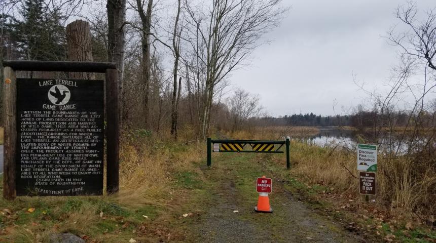
Entrance to the Lake Terrell Game Range
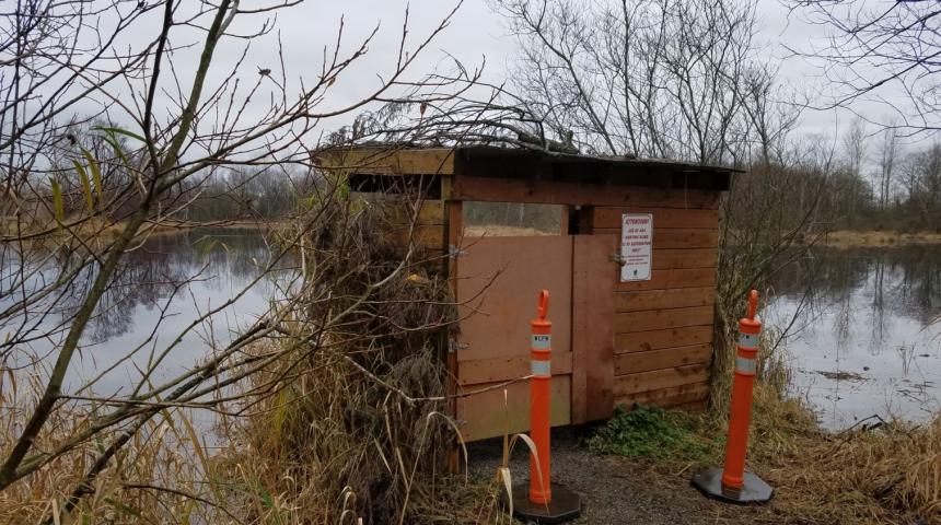
View of the ADA hunting blind
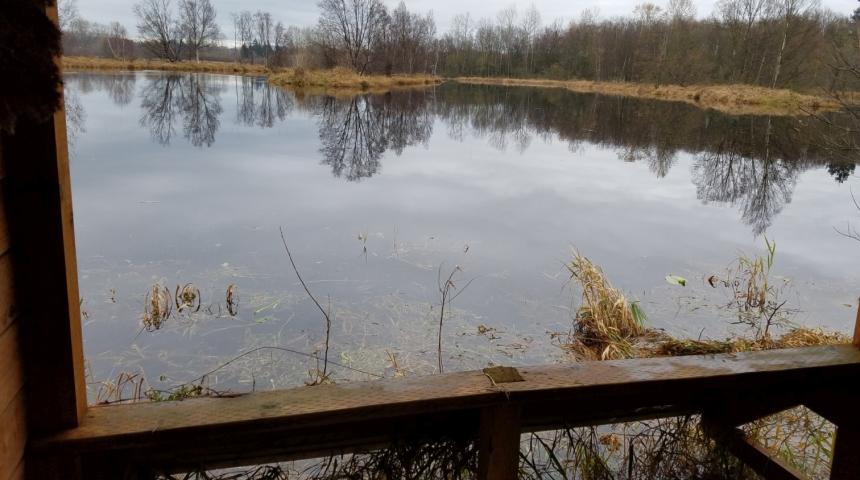
View of the lake from inside the blind
Nooksack Unit - Shady Lane ADA Blind
ADA certified permanent wooden blind is located on the Nooksack Unit of the Whatcom Wildlife Area on the edge of a man-made pond. The pond has a hard plastic liner bottom and varies 1.5 feet on edge to 4 feet deep in the middle. Two metal pipes have been installed in front of the blind for wind duck poles.
Do not install your own wind duck poles. You will puncture the pond liner if you do so. No chairs or seats are provided in blind.
Reserve using our Hunt by Reservation system.
Driving directions:
- From Bellingham, north on I-5 to exit 260, head west on Slater Road for 1/8th mile, then turn left onto Rural Avenue.
- Go 1 mile, then turn right onto Shady Lane and go approximately 1/2 mile. Access gate is located at end of Shady Lane.
- Turn left after entering gate and continue 100 yards to parking area. Blind is located 50 yards from parking area to the West through notch in berm with compact gravel trail.
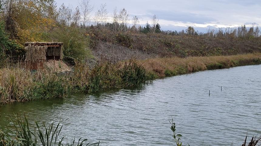
View of the hunting blind and the lake
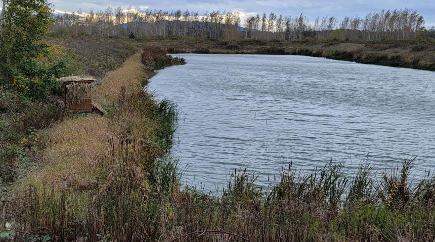
View of the hunting blind and the lake
Southwest Washington (Region 5)
Vancouver Lake-Shillapoo Area
Two blinds are located around the Shillapoo Wildlife Area. All goose hunters in this county must be certified by WDFW to hunt geese. Call Olympia or the WDFW Region 5 Office for information about goose testing. The one in the south unit is for geese; both are removed and replaced each season because of flooding in the area. These areas are also pheasant release sites. The blinds are installed around early December until the end of the waterfowl season. Register with the Wildlife Area Manager in the Vancouver Region 5 Office to obtain an access permit and a key for the gates.
Call the Wildlife Area Manager in advance at 360-696-6211 to reserve the blind and make arrangements to obtain the key.
Driving directions:
- From I-5 north of Vancouver, take the Fourth Plain Boulevard exit and head west to Fruit Valley Road.Turn right and go to Laframbois Road.Turn left. Follow the road to the Wildlife Area parking lot. The blind is usually about ½ mile from the gate depending on the level of the lake.
- The other blind is located in the south unit of the Shillapoo Wildlife Area.
- Follow Fourth Plain west until it turns into SR-501.At the fork in the road, go straight past the Vancouver Park entrance about two miles, watching for a gate on the left side of the road. Open the gate and go down a steep hill about 70 yards to the blind.
Ridgefield National Wildlife Refuge
This blind is managed by and located in the refuge area. All goose hunters in this county must be certified by WDFW to hunt geese. Call Olympia or the WDFW Region 5 office for information about goose testing, and learn more about hunting on the refuge.
Call the Ridgefield Office in advance at 360-887-4106 for more information about their hunting opportunities and reservation system.
Driving directions:
- Traveling on I-5 north of the Vancouver area, take the Ridgefield exit and go west toward the town of Ridgefield.
- The office is in town, not on the refuge, which is a few miles from the office.
Coastal Washington (Region 6)
Willapa National Wildlife Refuge Goose Blind
Located on refuge land in the Riekkola Unit, the blind is managed by the Willapa Refuge. Call the refuge office in advance at 360-484-3482 for more information about their hunting rules, opportunities and reservation system. This area is for goose hunting only. All goose hunters in this county must be certified by WDFW to hunt geese. Call Olympia or the Region 6 office for information about goose classes.
Driving directions:
Follow SR-101 south from Raymond and South Bend about 35 miles toward the refuge area. The office is located along SR-101 about 7 miles west of the SR-4 and SR-101 intersection. The hunting areas are in different locations away from the office.
Chehalis Wildlife Area
This blind is located on the Chehalis Wildlife Area, south of SR-12 and 2.5 miles west of Elma. The blind is situated at the end of a 300’ long paved trail and overlooks a small pond. The area floods regularly and some portions of the trail and blind may be submerged when the Satsop River is at flood stage. Under these conditions a small boat may be hand launched near the parking area, and the blind also accessed by boat. Decoys can be put out using chest waders or by boat.
Caution: The drop-off is gradual at the pond that the blind overlooks. However, the pond immediately to the north is a former gravel pit and has a steep drop, be cautious.
For more information contact the Olympic-Willapa Hills Wildlife Area at 360-533-5676.
Driving directions:
- From HWY-12 turn south on to Schouweiler Road.
- The road immediately curves to the right, stay on this road for 1/4 mile.
- Take a left at the T and continue for another 1,000 feet, the road ends at the parking area.
- Follow the paved trail to the blind.
John's River Blind
This blind is located on the Johns River Unit of the Johns River Wildlife Area, 6.5 miles east of Westport. Situated on the back side of the levee, the blind overlooks a large swath of land that is regularly mowed and to some degree is seasonally flooded. Flood waters typically remain in the ditch near the blind.
For more information contact the Olympic-Willapa Hills Wildlife Area at 360-533-5676.
Driving directions:
- From SR-105 turn south on to Johns River Road.
- Follow Johns River Road for 250 yards and then turn left onto Game Farm Road.
- In another 200 yards turn right towards the Johns River Boat Launch and parking area.
- Park here and follow the paved trail for .6 mile to the blind.